

![]()
Geographic Progression of The American Revolution
The American Revolution (1775-83) is also known as the American Revolutionary War and the U.S. War of Independence.
On July 4, 1776, America’s Thirteen Colonies declared that they were no longer part of Britain. The British disagreed. A war between Britain and the Thirteen Colonies began as a result of this disagreement. This war was known as the American Revolution or the War of Independence. (From “Our Land and People”, Patricia Shields-Ramsay, Douglas Ramsay)
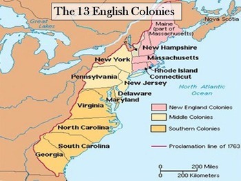
The location of the original thirteen English Colonies on the east coast of what is now known as the United States of America.
In order to understand the origins and progression of the American Revolutionary War, we will look at the locations of various battles during each stage of the war. From this data, we can begin to understand where the battles were taking place, where they moved to, and try and understand the events surrounding them. To begin, we first need to download an open data set from Wikipedia that contains the locations and other information about the battles.
Select the code cell below, then click the ▶Run button in the toolbar to download and display the data.
url = 'https://en.wikipedia.org/wiki/List_of_American_Revolutionary_War_battles'
import pandas as pd
revolution_data = pd.read_html(url)[17] # get the 18th table from the page
revolution_data
| Battle | Date | Colony/State | Outcome | |
|---|---|---|---|---|
| 0 | Powder Alarm* | September 1, 1774 | Massachusetts | British soldiers remove military supplies |
| 1 | Storming of Fort William and Mary* | December 14, 1774 | New Hampshire | Patriots seize powder and shot after brief ski... |
| 2 | Battles of Lexington and Concord | April 19, 1775 | Massachusetts | Patriot victory: British forces raiding Concor... |
| 3 | Siege of Boston | April 19, 1775 –March 17, 1776 | Massachusetts | Patriot victory: British eventually evacuate B... |
| 4 | Gunpowder Incident* | April 20, 1775 | Virginia | Virginia governor Lord Dunmore removes powder ... |
| ... | ... | ... | ... | ... |
| 253 | Action of 2 January 1783 | January 2, 1783 | Hispaniola | Inconclusive |
| 254 | Action of 22 January 1783 | January 22, 1783 | Virginia | British victory |
| 255 | Action of 15 February 1783 | February 15, 1783 | Guadeloupe | British victory |
| 256 | Action of 17 February 1783 | 17 February 1783 | Cuba | British victory |
| 257 | Recapture of the Bahamas | 14–18 April 1783 | Bahamas | British victory |
258 rows × 4 columns
From the table above we see that there is a lot of information to digest. There are 253 rows and four columns. The columns are the name of the battle, the date of the battle, where it took place, and the consequences of that battle.
Next we are going to look up latitude and longitude values for each of the listed locations.
# import and set up libraries
!pip install geopy --user
from geopy.geocoders import Nominatim
from geopy.extra.rate_limiter import RateLimiter
locator = Nominatim(user_agent='Callysto Geocoder')
geocode = RateLimiter(locator.geocode, min_delay_seconds=.1)
location_data_dictionary = {} # an empty dictionary that we will add to
# loop through the unique locations in the previous dataframe and geocode their location
for place in revolution_data['Colony/State'].unique():
    #location = locator.geocode(place) # without rate limiting
    location = geocode(place)
    print(location)
    location_data_dictionary.update({place:location})
# clear the screen of the progress we were printing
from IPython import display
display.clear_output()
# create the dataframe
location_data = pd.DataFrame(data=location_data_dictionary).transpose()
location_data.rename(columns={0:'Location', 1:'Coordinates'}, inplace=True)
location_data
| Location | Coordinates | |
|---|---|---|
| Massachusetts | Massachusetts, United States of America | (42.3788774, -72.032366) |
| New Hampshire | New Hampshire, United States of America | (43.4849133, -71.6553992) |
| Virginia | Virginia, United States of America | (37.1232245, -78.4927721) |
| New York | New York, United States of America | (40.7127281, -74.0060152) |
| Quebec | Québec, Canada | (52.4760892, -71.8258668) |
| ... | ... | ... |
| Delaware Bay | Delaware Bay, Cumberland County, New Jersey, U... | (39.247595399999994, -75.30105997051399) |
| Hispaniola | La Hispaniola, Constanza, La Vega, República D... | (18.77858115, -70.5427697709766) |
| Cape May | Cape May, Cape May County, New Jersey, 18204, ... | (38.9351126, -74.9060053) |
| Guadeloupe | Guadeloupe, France | (16.2490067, -61.5650444) |
| Cuba | Cuba | (23.0131338, -80.8328748) |
62 rows × 2 columns
Geographic View of The American Revolution
Now that we have some location data about the Revolutionary War battles, let’s put it on a map.
# join our two dataframes together
map_data = revolution_data.join(location_data, on='Colony/State')
# split the Coordinates column into Latitude and Longitude
map_data[['Latitude','Longitude']] = pd.DataFrame(map_data['Coordinates'].tolist(), index=map_data.index)
# create the map
import folium
battle_map = folium.Map(location=[50, -50], zoom_start=2)
for i, row in map_data.iterrows():
    location=[row['Latitude'], row['Longitude']]
    battle_map.add_child(folium.Marker(location, tooltip=row['Battle'], popup=row['Date']))
battle_map
It is interesting to note that that not all of the battles took place in the United States.
We can list the battles that took place in Canada.
map_data[map_data['Location'].str.contains('Canada')]
| Battle | Date | Colony/State | Outcome | Location | Coordinates | Latitude | Longitude | |
|---|---|---|---|---|---|---|---|---|
| 10 | Siege of Fort St. Jean | September 17 –November 3, 1775 | Quebec | Patriot victory: Patriots capture British forc... | Québec, Canada | (52.4760892, -71.8258668) | 52.476089 | -71.825867 |
| 11 | Battle of Longue-Pointe | September 25, 1775 | Quebec | British victory | Québec, Canada | (52.4760892, -71.8258668) | 52.476089 | -71.825867 |
| 18 | Battle of Quebec | December 31, 1775 | Quebec | British victory: British repulse Patriot assau... | Québec, Canada | (52.4760892, -71.8258668) | 52.476089 | -71.825867 |
| 23 | Battle of Saint-Pierre | March 25, 1776 | Quebec | Patriot victory | Québec, Canada | (52.4760892, -71.8258668) | 52.476089 | -71.825867 |
| 25 | Battle of The Cedars | May 18–27, 1776 | Quebec | British victory | Québec, Canada | (52.4760892, -71.8258668) | 52.476089 | -71.825867 |
| 26 | Battle of Trois-Rivières | June 8, 1776 | Quebec | British victory: Patriots forced to evacuate Q... | Québec, Canada | (52.4760892, -71.8258668) | 52.476089 | -71.825867 |
| 37 | Battle of Fort Cumberland | November 10–29, 1776 | Nova Scotia | British victory | Nova Scotia, Canada | (45.1960403, -63.1653789) | 45.196040 | -63.165379 |
| 107 | Battle of Chillicothe | May 1779 | Quebec | Patriot victory | Québec, Canada | (52.4760892, -71.8258668) | 52.476089 | -71.825867 |
| 154 | Battle of Pekowee | August 8, 1780 | Quebec | Patriot victory | Québec, Canada | (52.4760892, -71.8258668) | 52.476089 | -71.825867 |
| 170 | La Balme's Defeat | November 5, 1780 | Quebec | British-Iroquois victory | Québec, Canada | (52.4760892, -71.8258668) | 52.476089 | -71.825867 |
| 199 | Naval battle of Louisbourg | July 21, 1781 | Nova Scotia | Franco-Patriot victory | Nova Scotia, Canada | (45.1960403, -63.1653789) | 45.196040 | -63.165379 |
| 203 | Lochry's Defeat | August 24, 1781 | Quebec | British-Iroquois victory | Québec, Canada | (52.4760892, -71.8258668) | 52.476089 | -71.825867 |
| 234 | Crawford expedition | May 25-June 12, 1782 | Quebec | British-Iroquois victory | Québec, Canada | (52.4760892, -71.8258668) | 52.476089 | -71.825867 |
| 235 | Naval battle off Halifax | May 28–29, 1782 | Nova Scotia | British victory | Nova Scotia, Canada | (45.1960403, -63.1653789) | 45.196040 | -63.165379 |
| 236 | Raid on Chester | June 30, 1782 | Chester, Nova Scotia | British victory | Chester, Chester District Municipality, Nova S... | (44.5413322, -64.2411853) | 44.541332 | -64.241185 |
| 237 | Raid on Lunenburg | July 1, 1782 | Nova Scotia | Patriot victory | Nova Scotia, Canada | (45.1960403, -63.1653789) | 45.196040 | -63.165379 |
| 239 | Hudson Bay Expedition | August 8, 1782 | Rupert's Land | Franco-Patriot victory | Anglican Centre, Diocese of Rupert's Land, 935... | (49.8345313, -97.14746377135569) | 49.834531 | -97.147464 |
We are also interested in looking at the battles by year, so we will create a year column from the last four characters of the Date column.
map_data['Year'] = map_data['Date'].str[-4:]
map_data
| Battle | Date | Colony/State | Outcome | Location | Coordinates | Latitude | Longitude | Year | |
|---|---|---|---|---|---|---|---|---|---|
| 0 | Powder Alarm* | September 1, 1774 | Massachusetts | British soldiers remove military supplies | Massachusetts, United States of America | (42.3788774, -72.032366) | 42.378877 | -72.032366 | 1774 |
| 1 | Storming of Fort William and Mary* | December 14, 1774 | New Hampshire | Patriots seize powder and shot after brief ski... | New Hampshire, United States of America | (43.4849133, -71.6553992) | 43.484913 | -71.655399 | 1774 |
| 2 | Battles of Lexington and Concord | April 19, 1775 | Massachusetts | Patriot victory: British forces raiding Concor... | Massachusetts, United States of America | (42.3788774, -72.032366) | 42.378877 | -72.032366 | 1775 |
| 3 | Siege of Boston | April 19, 1775 –March 17, 1776 | Massachusetts | Patriot victory: British eventually evacuate B... | Massachusetts, United States of America | (42.3788774, -72.032366) | 42.378877 | -72.032366 | 1776 |
| 4 | Gunpowder Incident* | April 20, 1775 | Virginia | Virginia governor Lord Dunmore removes powder ... | Virginia, United States of America | (37.1232245, -78.4927721) | 37.123224 | -78.492772 | 1775 |
| ... | ... | ... | ... | ... | ... | ... | ... | ... | ... |
| 253 | Action of 2 January 1783 | January 2, 1783 | Hispaniola | Inconclusive | La Hispaniola, Constanza, La Vega, República D... | (18.77858115, -70.5427697709766) | 18.778581 | -70.542770 | 1783 |
| 254 | Action of 22 January 1783 | January 22, 1783 | Virginia | British victory | Virginia, United States of America | (37.1232245, -78.4927721) | 37.123224 | -78.492772 | 1783 |
| 255 | Action of 15 February 1783 | February 15, 1783 | Guadeloupe | British victory | Guadeloupe, France | (16.2490067, -61.5650444) | 16.249007 | -61.565044 | 1783 |
| 256 | Action of 17 February 1783 | 17 February 1783 | Cuba | British victory | Cuba | (23.0131338, -80.8328748) | 23.013134 | -80.832875 | 1783 |
| 257 | Recapture of the Bahamas | 14–18 April 1783 | Bahamas | British victory | The Bahamas | (24.7736546, -78.0000547) | 24.773655 | -78.000055 | 1783 |
258 rows × 9 columns
We can now animate those battles by the year that they took place. The year can be controlled by adjusting the slider on the bottom of the map below, or by simply pressing the play button. Look at the map below and observe the progress of battles that took place.
If you hover your mouse over the battle location, you can see the name of the battle. You can also zoom in and out with the buttons at the top right.
import plotly.express as px
fig = px.scatter_geo(map_data, lat='Latitude', lon='Longitude', animation_frame='Year', hover_name='Battle')
fig.show()
Using this interactive map, you can observe the progression of the American Revolution in North America in terms of the battles fought each year. Pay particular attention to the battles taking place in Quebec, the Maritime provinces, and along the Saint Lawrence River.
Questions
Use the slider and hover over the battles on the map above, which battles were fought in what is now Canada?
Why did some battles of the American Revolution take place in Quebec?
Choose one of those battles and study it further. How might that battle have shaped Canada as we know it today?
The Progression of the War
While the map above makes it easy to see where and when various battles were fought during the American Revolution, sometimes it’s to look at different visualizations. The following bar chart displays how many battles took place each year.
import cufflinks as cf
cf.go_offline()
by_year = map_data.groupby('Year').count()['Battle']
by_year.iplot(kind='bar', yTitle='Number of Battles', xTitle='Year', title='Battles per Year')
We can see that the year 1777 had the most battles out of the entire war. This is because 1776-1777 was the beginning of the British counter offensive, and British forces made considerable progress against the Americans.
Questions
1778 has about half as many battles as 1777, the year of the British counter offensive. What is the reason for this?
1780 has the second most battles in a year. What events lead to this year having as many battles as it did?
American Revolution Battle Locations
We can also chart the number of battles by location.
by_location = map_data.groupby('Location').count()['Battle'].sort_values()
by_location.iplot(kind='barh', margin=(400,0,0,50), dimensions=(800,1100), xTitle='Number of Battles', title='Battles by Location',)
Summary
Using data from Wikipedia, we were able to visualize the locations and progress of the American Revolution, and also discover how many battles took place each year.